platform
Creates a platform object related to the radar scenario.
| Library |
|
Description
Function platform creates a system object EngeeRadars.Platform related to the radar scenario radarScenario. Sensors can be installed on the platform that detect signals or emit them as part of a radar scenario. The characteristics of the platform (signatures) can be set in the form of the effective scattering area, the strength of the target, or the intensity of infrared radiation. Platforms can be modeled as points or rectangular parallelepipeds using the property Dimensions, and also use the property PoseEstimator to determine the current spatial position of the platform relative to the local coordinate system of the scenario. For any platform, you can set the trajectory using system objects. EngeeRadars.KinematicTrajectory
or EngeeRadars.geoTrajectory.
Use the functions targetPoses, targetFreeSpacePaths and targetTwoRayPaths to calculate the position and orientation of all targets, signal propagation in free space, and for a two-beam model in a scenario relative to the observing platform.
Syntax
Function call
-
plat = platform(scenario,Name=Value)— creates a platform system objectplatwith properties specified by one or more arguments of the typeName=Value. Unspecified properties retain their default values.
Arguments
Input arguments
# scenario — radar scenario
+
radarScenario object
Details
The object of the radar scenario radarScenario, to which the platform being created is being added.
Input arguments «name-value»
Specify optional argument pairs as Name=Value, where Name — the name of the argument, and Value — the appropriate value. Type arguments «name-value» they should be placed after the other arguments, but the order of the pairs does not matter. You can specify multiple pairs «name-value».
# PlatformID is the platform identifier
+
scalar
Details
The platform ID, set as a positive integer.
This argument can be set as follows:
scene = EngeeRadars.radarScenario()
plat = EngeeRadars.platform(scene)
plat.PlatformID = 2
Or through the platform’s system object:
scene = EngeeRadars.radarScenario()
plat = EngeeRadars.Platform(scene, 2)| Типы данных |
|
# ClassID is the platform classification identifier
+
0 (by default) | scalar
Details
The platform classification ID, set as a non-negative integer. You can define your own platform classification scheme and assign values to them. ClassID according to this scheme. Meaning 0 reserved for an object whose class is unknown or not assigned.
| Типы данных |
|
# Position — current position of the platform
+
[0 0 0] (by default) | vector | the 1 by 3 matrix
Details
The current position of the platform, set as a three-element vector or matrix of size 1 on 3.
-
If for the script property
IsEarthCenteredthe value is setfalse, the position is expressed in Cartesian coordinates[x y z]in meters. -
If for the script property
IsEarthCenteredthe value is settrue, the position is expressed in geodetic coordinates[latitude, longitude, altitude], where latitude and longitude are set in degrees, and altitude is set in meters.
The position is determined by the trajectory of the platform, set by the property Trajectory.
| This argument is read-only. |
| Типы данных |
|
# Orientation — the current orientation of the platform
+
[0 0 0] (default) | vector | the 1 by 3 matrix
Details
The current orientation of the platform in degrees, set as a three-element vector or matrix of size 1 on 3. Orientation is expressed by the angles of rotation [yaw, pitch, roll] when switching from the local coordinate system to the associated coordinate system of the platform. The orientation is determined by the trajectory of the platform, set by the property Trajectory.
| This argument is read-only. |
| Типы данных |
|
# Dimensions — the dimensions of the platform and the offset of the origin
+
(Length = 0, Width = 0, Height = 0, OriginOffset = [0 0 0]) (by default) | named tuple
Details
The size of the platform and the offset of the origin, set as a named tuple. The tuple contains fields Length, Width, Height and OriginOffset for a rectangular parallelepiped approximating the dimensions of the platform. By default, the property Dimensions It is a tuple in which the values of all fields are zero, which corresponds to the point model.
Field OriginOffset It is a position vector directed from the center of the parallelepiped to the origin of the platform coordinate system. Meaning OriginOffset It is set in the coordinate system of the platform. For example, if the origin of the platform coordinates is in the center of the back face of the parallelepiped, as shown in the figure, then for OriginOffset the value should be set .
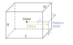
| Field | Description | Default value |
|---|---|---|
|
The size of a rectangular parallelepiped along the axis |
|
|
The size of a rectangular parallelepiped along the axis |
|
|
The size of a rectangular parallelepiped along the axis |
|
|
The position of the origin of the platform coordinate system relative to the center of the rectangular parallelepiped |
|
| Типы данных |
|
# Trajectory — platform movement
+
the KinematicTrajective object (by default) | the geoTrajective object
Details
The movement of the platform, set as a system object EngeeRadars.KinematicTrajectory or EngeeRadars.geoTrajectory. The trajectory object determines the change in time of the position and velocity of the origin of the coordinate system of the platform, as well as the orientation of this system relative to the reference frame of the scenario.
-
If for the script property
IsEarthCenteredthe value is setfalse, use the object EngeeRadars.KinematicTrajectory. -
If for the script property
IsEarthCenteredthe value is settrue, use the object EngeeRadars.geoTrajectory.
# PoseEstimator — evaluator of platform position
+
the insensor object
Details
The platform position estimator, set as a position estimation object. The evaluator determines the position of the platform relative to the local coordinates of the scenario in the NED system (north-east-down). The interface of any position estimator must match the interface of the object. EngeeRadars.insSensor. By default, the accuracy parameters of the position estimator are set to zero.
# Emitters — emitters on the platform
+
vector of objects
Details
Radiators installed on the platform, specified as a vector of radiator objects of the type EngeeRadars.radarEmitter or EngeeRadars.sonarEmitter.
# Sensors — sensors on the platform
+
vector of objects
Details
Sensors installed on the platform, specified as a vector of sensor objects of the type EngeeRadars.radarDataGenerator or EngeeRadars.radarTransceiver.
# Signatures — platform signatures
+
the rcsSignature object
Details
Platform signatures set as a system object EngeeRadars.rcsSignature. The signature characterizes the reflection or radiation parameters of the platform, such as the effective scattering area, the strength of the target, or the intensity of infrared radiation.
Output arguments
# plat — platform object
+
system object
Details
A platform object containing the following properties:
-
PlatformID— platform ID; -
ClassID— ID of the platform classification; -
Position— current spatial position of the platform; -
Orientation— current platform orientation; -
Dimensions— the size of the platform and the offset of the origin; -
Trajectory— platform movement; -
PoseEstimator— platform position evaluator; -
Emitters— radiators installed on the platform; -
Sensors— sensors installed on the platform; -
Signatures— characteristics of the platform.
Methods
For the EngeeRadars.Platform system object
targetPoses
|
Calculation of the position and orientation of targets relative to the platform
|