Global Reference Atmosphere
Determination of atmospheric parameters by altitude, latitude, longitude and season according to GOST R 53460-2009.
blockType: SubSystem
|
Path in the library: |
Description
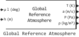
Block Global Reference Atmosphere implements a digital model of the global reference atmosphere according to GOST R 53460-2009. For the specified geopotential altitude and month, the block determines the average latitude values of temperature, air pressure and density, the speed of sound, and, if necessary, wind parameters.
The model supports height ranges from 0 before 30 km and from 0 before 120 km. In the range of 0 before 30 km can take into account the set random deviations of atmospheric parameters and choose the method of their mutual redefinition. If accounting for random deviations is disabled, the block returns the average tabular values.
The parameter values are calculated according to the GOST tables using linear interpolation method «Linear point-slope». For longitude interpolation, the midpoints of the tabular ranges are used as reference points.: −150, −90, −30, 30, 90 and 150°. Therefore, on the border of adjacent ranges, the result is the average of the corresponding tabular values. The longitude can be set in one of two ranges: from −180 before 180° or from 0 before 360°. In the first case, negative values correspond to the western longitude, and positive values correspond to the eastern longitude. Values are higher 180° the unit converts to equivalent values the range from −180 before 180°, for example 270° — in −90°. Values outside the specified ranges are not allowed.
If the value of the argument exceeds the boundaries of the tabular data, the extrapolation method is used. «Clip»: the block returns the value at the nearest border of the table. In particular, the GOST tables contain data for latitudes from −80 before 80°, therefore, for latitudes below −80° values are used for −80°, and for latitudes above 80° — values for 80°.
Ports
Input
#
μ l (deg)
—
latitude and longitude
two-element vector
Details
Latitude and longitude, measured in degrees. The input signal must be a vector of two elements: the first element specifies latitude, the second element specifies longitude. The longitude can be set in the range from −180 before 180° or from 0 before 360°. Values are higher 180° the unit converts to equivalent values the range from −180 before 180°.
| Data types |
|
| Complex numbers support |
No |
#
h (m)
—
geopotential height
scalar
Details
Geopotential height, measured in meters. The input signal must be a scalar.
| Data types |
|
| Complex numbers support |
No |
Output
#
T (K)
—
average latitude temperature
scalar
Details
The average latitude temperature for a given altitude, latitude, longitude, and season, measured in kelvin.
| Data types |
|
| Complex numbers support |
No |
#
a (m/s)
—
The speed of sound
scalar
Details
The speed of sound, measured in m/s. The value is calculated according to the formula according to clause 14 of GOST 4401-81:
where — average latitude temperature.
| Data types |
|
| Complex numbers support |
No |
#
P (Pa)
—
average latitude pressure
scalar
Details
The average latitudinal pressure for a given altitude, latitude, longitude, and season, measured in Pa.
| Data types |
|
| Complex numbers support |
No |
#
ρ (kg/m3)
—
average latitudinal air density
scalar
Details
The average latitudinal air density for a given altitude, latitude, longitude, and season, measured in kg/m3.
| Data types |
|
| Complex numbers support |
No |
# VWE (m/s) is the average latitude wind speed
scalar
Details
The average latitudinal zonal wind speed for a given altitude, latitude, longitude, and season, measured in m/s.
Dependencies
To use this port, check the box Show wind parameters.
| Типы данных |
|
| Support for complex numbers |
None |
# VSN (m/s) is the average latitudinal wind velocity
+
scalar
Details
The average latitudinal wind velocity for a given altitude, latitude, longitude, and season, measured in m/s.
Dependencies
To use this port, check the box Show wind parameters, and for the parameter Altitude range — value 0 - 30 km.
| Типы данных |
|
| Support for complex numbers |
None |
# VS (m/s) is the average latitude velocity of the scalar wind
+
scalar
Details
The average latitudinal scalar wind velocity for a given altitude, latitude, longitude, and season, measured in m/s.
Dependencies
To use this port, check the box Show wind parameters, and for the parameter Altitude range — value 0 - 30 km.
| Типы данных |
|
| Support for complex numbers |
None |
Parameters
Main group
#
Altitude range —
height range
0 - 30 km | 0 - 120 km
Details
Select the height range in question:
-
0 - 30 km; -
0 - 120 km.
| Values |
|
| Default value |
|
| Program usage name |
|
| Tunable |
No |
| Evaluatable |
Yes |
#
Month —
month
January | February | March | April | May | June | July | August | September | October | November | December
Details
Select the month in question.
| Values |
|
| Default value |
|
| Program usage name |
|
| Tunable |
No |
| Evaluatable |
Yes |
# Show wind parameters — activation of ports related to wind parameters
Details
If for the parameter Altitude range the value is set 0 - 30 km selecting this option activates the output ports VWE (m/s), VSN (m/s) and VS (m/s).
If for the parameter Altitude range the value is set 0 - 120 km selecting this option activates only the output port VWE (m/s).
| Default value |
|
| Program usage name |
|
| Tunable |
No |
| Evaluatable |
Yes |
# Set random deviations — option for setting random deviations
Details
Check this box to activate the options. Random deviations of parameters and Overriding parameters.
Dependencies
To use this parameter, set for the parameter Altitude range meaning 0 - 30 km.
| Default value |
|
| Program usage name |
|
| Tunable |
No |
| Evaluatable |
Yes |
# Random deviations of parameters — random deviations of parameters
Details
A vector of random deviations for the parameters. The length of the vector can change depending on whether the checkbox is unchecked or checked. Show wind parameters.
Dependencies
To use this option, check the box Set random deviations.
| Default value |
|
| Program usage names |
|
| Tunable |
No |
| Evaluatable |
Yes |
#
Overriding parameters —
redefining parameters
Independent atmospheric parameters | Density redefinition | Pressure redefinition | Temperature redefinition
Details
Select the settings for recalculation «rejected» parameters:
-
Independent atmospheric parameters; -
Density redefinition; -
Pressure redefinition; -
Temperature redefinition.
| Values |
|
| Default value |
|
| Program usage name |
|
| Tunable |
No |
| Evaluatable |
Yes |